
Paddling the Slough
By Keith Daellenbach | Contributing Writer
In April, my wife, Amy, and I made a one-day voyage down the entire 19-mile length of the Columbia Slough’s primary waterway in our 14-foot Old Town brand polyethylene canoe. We started at quarter past eight in the morning on a Saturday, launching from Lakeshore Park at the east end of the shallow, 110-acre Fairview Lake. After paddling one mile across the lake, we portaged across NE Fairview Lake Way above the lake’s discharge at an approximately 2.5-foot impoundment dam and started down the Columbia Slough itself.
The Columbia River at Vancouver gauge level was 7.5 feet. This early in the year, the water level is adequately high and there is less aquatic vegetation and floating macrophytes and algae mats than exist July through early fall, which can slow progress considerably. It reached mid 70-degree Fahrenheit, was mostly sunny, and, for the most part, we had a light east wind at our backs.
Up to the NE 17th Ave. levee, the upper and middle slough is narrower and typically tree-lined with lots of natural habitat and wildlife. Along the three-mile stretch between the second levee and North Portland Road, the north shore of the waterway astride the levee lacks trees and riparian habitat; however, the five-mile stretch below North Portland Road to its confluence with the Willamette River has a rural, serene feel-. It’s a beautiful, wide waterway lined with black cottonwood and Oregon ash.
Planning Your Trip
Before you go, you must obtain a waterway access permit from the Oregon Department of Fish and Wildlife. A permit is required for all non-motorized watercrafts regardless of watercraft length. This permit funds waterway access improvement and aquatic invasive species prevention efforts.
Getting a watercraft can be a challenge but there are local options to rent a canoe or kayak from Alder Creek Kayak & Canoe (Jantzen Beach), Oregon River Rentals (Happy Valley), or eNRG Kayaking (Oregon City). Notably, the Columbia Slough Watershed Council’s (CSWC) offers multiple free outings each year including in bimarans which are two canoes strapped together for maximum stability.
Navigation Tips and Resources
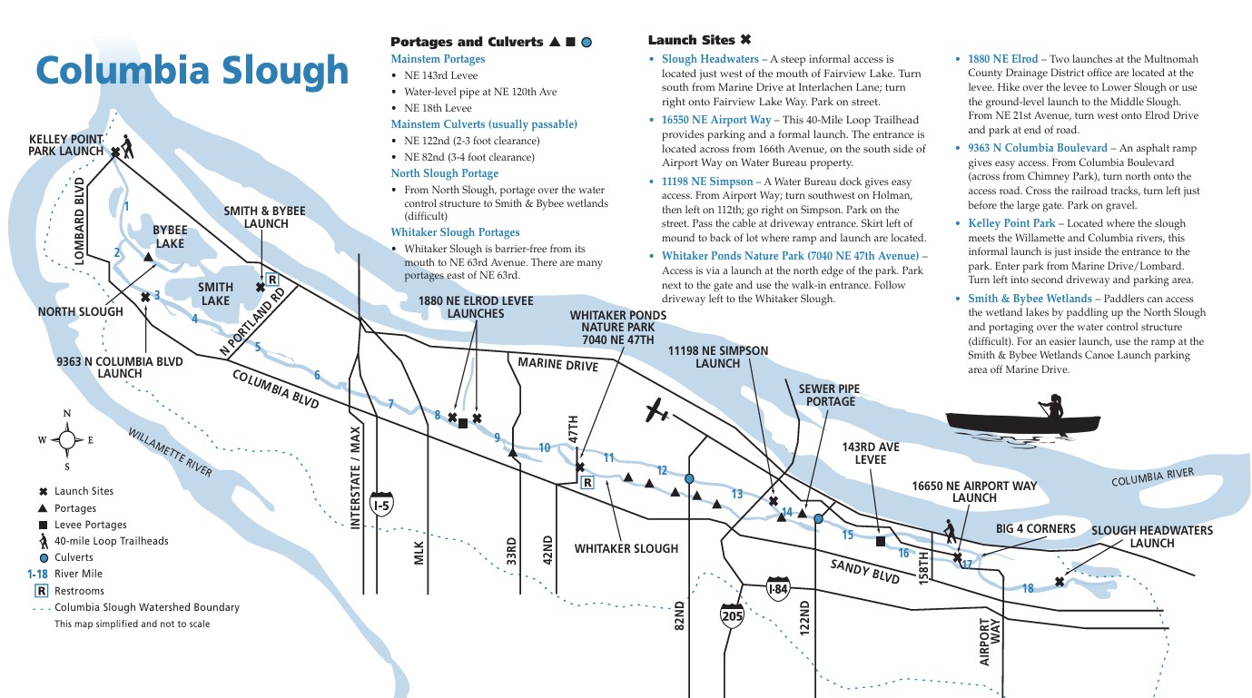
The Bureau of Environmental Services’ “A Paddler’s Access Guide, Columbia Slough” (2015) is an excellent overview to navigate the slough. It contains a map showing nine formal launch sites, like Whitaker Ponds Nature Park (26-acres, 7040 NE 47th Ave.) near Concordia, locations of two levee portages, the first at NE 143rd Ave. and the second at the northern extension of NE 17th Ave. at 1880 NE Elrod Drive, one water-level sewer pipe portage just below NE 122nd Ave. (there are five other above-ground pipe crossings but they are well above the water surface and require no portage), and two under-road culverts, one at NE 122nd Ave. and the other at NE 82nd Ave. (we paddled through both while remaining in our canoe).
Additional informal launch points can be viewed from the 32 bridges that cross the slough. Five rail tracks also cross the slough (two MAX light rail and three railroad). One strategy for a point-to-point transect through the slough is to place a locked bicycle at a takeout location and drive to the “top” with a watercraft, park, and put in for a bike return later (the locked watercraft remains at “bottom” for pickup later).
Do not miss the tremendous paddling opportunity in Smith and Bybee Lakes, one of the country’s largest urban freshwater wetlands (2,000-acres), which can also link, with a portage at the outlet of Bybee Lake, to the lower slough and Kelley Point Park, across the Willamette River from Sauvie Island. Kelley Point Park is a 90-acre, free-parking scenic wonderland that is culturally and spiritually significant to local indigenous tribes but do not swim here as it is at the confluence of two powerful rivers.
Safety Considerations
With your watercraft, wear a life jacket and carry an emergency whistle and headlamp as well as a bow and stern rope. A lightweight, two-wheeled canoe or kayak cart with ratchet strap is very helpful for portages as is a map, compass, and GPS with route waypoints to navigate the many waterway confluences in the slough. Leave a float plan that includes the route, vehicle description, participant contact information, and expected time duration with someone at home.
Check the weather and predictive tide chart at the Columbia at Vancouver gauge (USGS 14144700) on the slough as downstream speed slows, below the second levee at NE 17th Ave., for the final 8.5 miles to the Willamette River during two flood tides each day. While a second gauge (Columbia Slough at Portland, USGS 14211820) does not provide a prediction of slough levels, it does show current, past ebb and flood of tidal flow pattern, and current gauge height in the Smith and Bybee Lakes wetland.
Another excellent resource is the Columbia Slough Watershed Council’s (CSWC) “Nature in the City Columbia Slough” (ca. 2023) which offers an excellent informative map with over three dozen natural history and geographic references.
Years ago, following a bimaran outing with CSWC with our then very young son, Micah, we found and purchased our used canoe (named “The Spy” by a young Micah) from a family no longer needing it for a low price off Craigslist. That started nearly twenty years of exploring over 25 waterways and lakes throughout Oregon and southwest Washington. I hope the slough will inspire you too.
Keith Daellenbach is a mechanical engineer and outdoor enthusiast who loves mountain climbing, skiing, biking, canoeing, and beekeeping with his wife Amy and son Micah.