Council eyes multi-modal plan
 By Garlynn Woodsong
Chair, CNA LUTC
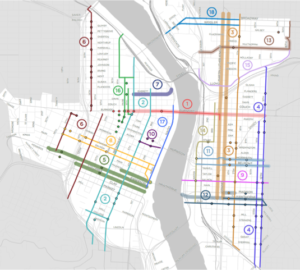
A new multi-modal transportation plan for downtown Portland, called the Central City In Motion Implementation Plan, was passed by City Council on November 15, 2018 by a vote of 3-0 (and Willamette Week reports that both Mayor Wheeler and Commissioner Fish would have voted yes on the plan, had they been present).
The plan includes 18 projects that are intended to increase the people-moving capacity of the central city’s transportation network, so that it will be able to accommodate the additional 40,000 households and 50,000 jobs that are expected to locate there between now and 2035.
According to the Portland Bureau of Transportation (PBOT), one lane can accommodate up to: 850 people per hour if used for automobiles; 2,000 people per hour in buses; or 2,500 people per hour as a protected bike lane.
Creating a complete, connected bicycle network is thus the most efficient way to allow the most additional people to move through the central city. It is no surprise, then, that all 18 projects include bicycle elements, as elements of street design that increase the number of people that a street can accommodate (throughput):
1. W Burnside St: From W 10th Ave to E 12th Ave. A Bus And Turn (BAT) lane, a series of crossing improvements, and protected bikeways will increase throughput 145%.
2. NW / SW Broadway St / 4th Ave. A signature north-south bike facility on the 4th Ave and Broadway couplet, and upgraded unsignalized pedestrian crossings in South Downtown, will increase throughput 65%.
3. NE / SE Grand / 6th / 7th. Bus/streetcar And Turn (BAT) lanes on MLK and Grand that will also accommodate freight, new pedestrian crossings of MLK and Grand, protected bike lanes on 7th Ave connecting it across the new Sullivan’s Crossing bridge, and the future Green Loop on 6th Ave, including new pedestrian crossings, will increase throughput 324%.
4. NE / SE 11th Ave / 12th Ave. A wider travel lane to better accommodate buses and trucks, a wide bike lane, and a series of pedestrian crossing and bus stop improvements will increase throughput 9%, and the wider travel lane will enable this corridor to accommodate freight.
5. SW Jefferson / Columbia / Madison. A BAT lane, bus stop improvements, and traditional bike lanes will increase throughput 74%.
6. NW / SW 12th / 14th / 17th. A protected bike lane on NW 14th from Burnside to Hoyt, and a wide bike lane from Hoyt to Savier; a two-way bikeway on SW 17th from Salmon to Alder, and a neighborhood greenway from Madison to I-405; and a protected bikeway on SW 12th from College to Stark, will increase throughput 18%.
7. NW Everett St to Steel Bridge. A BAT lane on Everett as it approaches the Steel Bridge, and a new Transit Priority Signal at the top of the ramp east of NW 1st Ave, will increase throughput by 68%.
8. SW Salmon / Taylor St / 1st St. Protected bike lanes that link the Hawthorne Bridge to Goose Hollow will increase throughput 156%.
9. SE Salmon. Extend the greenway from SE 12th to the Eastbank Esplanade.
10. SW Alder / Washington. Improving pedestrian and bicycle access to the Morrison Bridge by adding a short segment of two-way protected bikeway will increase throughput 294%.
11. SE Belmont / Morrison. Improve transit access and speed with new transit islands, improved pedestrian crossings, and protected bike lanes.
12. SE Hawthorne / Clay / Madison. Transit priority signals at intersections on Hawthorne and Madison, protected bike lanes on Hawthorne and Clay, and pedestrian crossing improvements will increase throughput 46%.
13. NE Multnomah / NE 16th. A Neighborhood Greenway on NE 16th, connecting an improved parking protected bike lane on NE Multnomah with NE Portland neighborhoods, will increase throughput 4%.
14. SE Water / Stark / 3rd. A two-way bikeway on Water Ave will provide a safe and convenient alternative to the often heavily used Eastbank Esplanade to access bridges and nearby destinations, increasing throughput 81%.
15. NW Lloyd Blvd. A two-way bikeway will provide a cycling connection from the Steel Bridge to NE 16th, increasing throughput 39%.
16. NW Park / 9th. Protected bike lanes on NW 9th will transition to a protected bike lane on Park, and new signalized crossings will remove barriers to walking and biking, increasing throughput 294%.
17. SW Naito. Implementing a year-round version of “Better Naito”, and adding smart signals to smooth auto access to I-5 at the Morrison Bridge, will increase throughput 94%.
18. NE Broadway / Weidler St. Protected or buffered bike lanes will prove safety and circulation from the Broadway Bridge to NE 7th Ave, increasing throughput 14%.
These 18 projects have been prioritized, with the most critical investments recommended for implementation over the next 5 years.
Funding for the projects comes from a variety of sources. $35 million is needed to build the first phase projects; of this, PBOT has $8.3 million secured from federal grants and local gas tax proceeds; $16.7 million pledged from TriMet; and $11 million from System Development Charges. There’s a gap of $10 million yet to fill; but the current gas tax sunsets in 2020, so it’s likely that more projects could be funded if it is extended beyond that date. This outcome is not guaranteed, however, so we will need to watch and use the first phase, then support PBOT in their quest for further funds if the first generation of projects proves a success.
Garlynn Woodsong lives on 29th Avenue, serves on the CNA board and is an avid bicyclist. He also is a dad who is passionate about the city his son will inherit. He is the planning + development partner with Cascadia Partners LLC, a local urban planning firm. Contact him at LandUse@ConcordiaPDX.org.